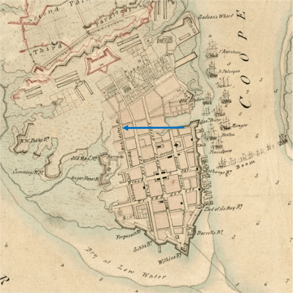
I began researching Charleston the old-fashioned way…the way I learned to do it at the St. Charles archives…the earliest timeframe first. Before settling on my block in Charleston as my home base, I began to accumulate copies online of old maps. I am going to share an old one here out of chronological sequence (and will show it again later) because it shows the limited usable space that Charleston had to grow a town on due to the high tide consequence of living in the Low Country. And, coincidentally, just now, I thought of a quote to use from a great book I will quote from often, Lowcountry at High Tide (1):
Early accounts of Charleston described a low-lying, hot, damp port city. The rivers “washed over two thirds of the town.” Wrote Alexander Hewatt in 1779, and “so low and level is the ground upon which CH is built, that the inhabitants are obliged to raise banks of earth, as barriers, to defend themselves against the higher floods of the sea.”
As you can see and surely already know, the original town was small and built where there was a patch of high ground just high enough. Archdale Street was the outer limit of the town on the west before the land turned to marsh crisscrossed with creeks. There were no notes with the map…but my guess is that the green areas are marsh and beige would be land with trees…but you get the idea.
A current look at the old map…
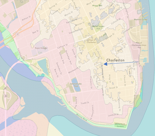
This map is from 2021 and shows…I think…again no text with it…the medium and darkest beige being the highest ground with King Street marching right up the middle… the spine of the peninsula….as it always does. The arrow again is approximating Market Street at Archdale…still central also.
New Flood Zone Maps – Charleston Livability
An odd thing about this map…it says Flood Zone Map 2021 and gives the Livability website address but when you go to the site, it is about Charleston flood maps but does not show this map!
The maps and insights into flooding zones are mostly on realty sites. Buyers wanting to know how safe a favored house might be. This site has some useful tips on evaluating floods, hurricanes, etc…. which I quote from at length. It is rather low key… (3)
“Now that doesn’t sound so drastic does it? Frankly, if I had to pick a natural disaster, I’d pick a hurricane over a tornado, earthquake, tsunami or mudslide any day. Why? Because you have time to get the heck out of its way. (The site goes on to give the FEMA definitions for insurance purposes ” based on cumulative probabilities, height of the land and proximity to water. There are lots of classifications, but the two we see most commonly on the Charleston Peninsula are AE and X, and on the Islands, AE and VE.)
AE Defined – Areas subject to inundation by the 1-percent-annual-chance flood event determined by detailed methods. Base Flood Elevations (BFEs) are shown. Mandatory flood insurance purchase requirements and floodplain management standards apply.
X Defined – Areas of minimal flood hazard, which are the areas outside the SFHA and higher than the elevation of the 0.2-percent-annual-chance flood…In this graphic below of Downtown Charleston – only the white spots are in the X zone…
The Chance of a bad Hurricane…
So, let’s start with the big stuff. Hurricanes! Fear of hurricanes hitting us is one of the most frequently expressed concerns of my clients moving here from other places. Understandable, yet frankly, overwrought. In 1989, Hurricane Hugo barreled ashore as a Category 4 hurricane, causing widespread destruction and devastation that took months (even years) of recovery effort. Since then, nearly THREE DECADES passed until we had another hurricane directly hit us – Hurricane Matthew of October 2016, a Category 1-2.
Here’s an excerpt from an excellent Post and Courier article from 2012 about flood insurance and the likelihood of a BIG HIT from a hurricane in our area.
Enough Already With The Fear-Mongering
A storm is brewing in the Atlantic; forecasters are fanning out along its projected path; it has a name. Beryl. Floyd. Hugo. Time for a gut check: Does your stomach tighten? After all, isn’t South Carolina a hurricane magnet?
Maybe not.
South Carolina’s vulnerability to hurricanes is much more nuanced than the headlines on the Weather Channel might suggest. Experts say based on historical trends, minimal hurricane-force winds or higher will touch some part of South Carolina every five years.
Minimal hurricanes typically aren’t catastrophes. It’s the Category 3 and above storms that knock a city off its foundation. The 60-mile area around Charleston has seen only two of these since 1851 (Hugo and the Hurricane of 1893).
Narrow the location even more, and the situation is even less worrisome. A Post and Courier report showed that when analysts study a specific location’s vulnerability, a coastal property owner would on average see catastrophic winds every 370 years or longer.
As we enter early hurricane season 2023, there is already one forming and heading north…fingers crossed…but like the realty people, optimistic.
- (1) Lowcountry at High Tide, A History of Flooding, Drainage, and Reclamation in Charleston, South Carolina by Christina Rae Butler, The University of South Carolina Press 2020
- (2) Map: 1780 Investiture Charleston Walled City…a ca. 1780 British map now among the collections of the U.S. Library of Congress from the sites’ 5 April 2016 post Occupied Charleston 1780-1782 https://walledcitytaskforce.org/page/3/
- (3) Flooding & Hurricanes | Useful Tips | Charleston SC | Kristin B. Walker, Realtor (charlestoninsideout.net)
