First, Dr. Sally Lorbach, Executive Director of Canterbury House, ended her brief history of the building of Canterbury in our monthly newsletter in 2022, with a surprise…for me, anyway…I will quote her:
“A couple of interesting facts about Canterbury House property prior to its construction…
- The property was a Presbyterian cemetery that moved to make way for the construction of Canterbury House.
- Canterbury House agreed to accept the financial responsibilities to maintain the grounds (at the new location) and face of the cemetery for 30 years (1969-1999). We did.
- In 1999, when I first joined Canterbury House…the Executive Director at the time and I sat with the leaders of the Presbyterian church, and in effect returned the responsibilities of the (new location of the) gravesite to the Presbyterian Church. Canterbury House remains grateful to the Presbyterian Church for recognizing the need for senior housing in downtown Charleston.
The last post was about the building of Canterbury’s new East Building in 2000 and how it took nine years of negotiating about where and how to locate Canterbury’s building amid claims for much needed parking lots for the city vs the also much needed senior housing. Now, we can see that the same issue plagued the building of the older high rise, West…built in 1970.
I immediately set to work to see what I could find…this will take several posts, but it will be worth it! And…we will immediately be back 50 years in time and will be reminded that nothing changes….
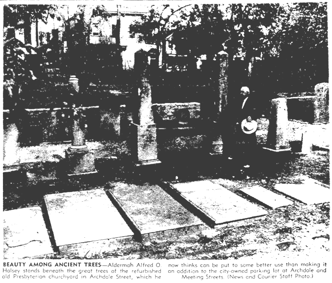
First, of course, I found an article on the cemetery in the newspaper…this time, The News and Courier in 1953…70 years ago…
I will quote from the article, and it will take a few posts to do it justice….

The City of Charleston has a new beauty spot on its hands. And Alderman Alfred O. Halsey says he hopes it doesn’t have to become a parking lot.
For Mr. Halsey, this is a change of opinion. Some weeks ago, when the city acquired for $1,000 the old Presbyterian burial ground in Archdale Street just north of West Street. Mr. Halsey envisioned it as a useful addition to the newly developed municipally owned parking lot at Archdale and Market Street.
(So, the city parking lot on the corner with parking meters added on was purchased in the 1950s..probably when the Market Street extension went in…also in the 1950s. (more later) The city had had the parking lot on the corner that all the dealing was about with Canterbury in the late 60s, for about 15 years. See below. CMF)
But that was before some 30 truckloads of tin cans, beer and whisky bottles and all sorts of unmentionable debris were carted away from the burial ground, which for many years stood next to a ramshackle Negro tenement, now demolished.
It was also before the ancient tombstones, hardly one less than a century old, had been moved to the rear of the churchyard. Here they were placed between walks of crushed stone and guarded by a low fence…
When the cleanup operation was completed, Mr. Halsey saw that what he had was a wonderfully pleasant park, its grass green, its 11 tall trees restfully shady. And the whole was enclosed by a tall, thick, old-fashioned Charleston brick wall built early in the 19th Century, with a wrought iron fence in front still in excellent repair. “I sat on this wall,” Mr. Halsey said, “and I thought what a pity it would be to destroy all this beauty especially since we don’t know if we will need it.
“We were supposed to have had parking meters in the new lot next door, but they haven’t been installed. I don’t quite know why. But until the meters are in, we don’t know if the lot will be in demand once people have to pay to park there.
“Anyway, I suppose I’ve got too much sentiment to want to see these great trees pulled up. It seems to me that this place is worth more now as a beauty spot than as a place to park a few more cars. You couldn’t find anywhere in Charleston a virgin lot such as this. You couldn’t rebuild that brick wall for $8,000. So when we got this far I just told the men to stop. I don’t know what should be done with this lot now. But I don’t want to see it destroyed until we know where we are going with the parking lot.”
As Dr. Sally said, though, the group that is getting ready to build Canterbury West…the tall one…took on the responsibility for caring for those gravestones what were moved first to the back of the lot and then again sometime after 1953 when the article was written and 1969 when Canterbury was being negotiated, they were moved to another cemetery.
But now…for those obsessed…we know a lot more…
- The City bought the lot including the cemetery shortly before the article was written in 1953 as a possible addition to the municipal lot purchased at Archdale and Market for a parking lot…for only $1000…which tells us the shape the area was in. But had yet to be developed.
- The City and or Canterbury had or soon would demolish old buildings that stood in its way…many of those buildings had probably been condemned.
I ran across this map….hard to read but you get the picture. It was hand drawn in 1969 by someone else planning to expand into the area…more later.
I’m showing the whole drawing, though a bit confusing…but for the Charlestonians, it might be interesting. The main point for me, is on the right edge near the top, the outlined in pencil rectangle that says “High Rise for” across the top section and “Elderly” sort of sprawling across the other buildings…but with the church cemetery clearly shown.

.
