Here we get into the problem with chronology, again…for my little dig on my small block in Charleston, SC. But we will soldier on… Then I will swing back and do a social dig on the block and neighborhood and life.
Because as we went from 2000 when Canterbury East was built…back to 1970 when Canterbury West (the tall building) was built and then again back to the 1950s to learn about the cemetery that was cleared from the block before building began, what have we done…we have skipped right over the 1960s and 70s and all those years brought to Charleston…not to mention Hurricane Hugo in the 80s.
But I want to finish the physical lay of the land back to the 1950s first because a physical change happened to my block that allowed for the changes already documented in earlier posts.
The below photo is dated ca 1955. It is taken from the east end of Canterbury West showing the city parking lot with the meters and Canterbury’s parking…what is now Canterbury East. We are facing Archdale Street and three very old buildings I will get to later. For now, it is necessary to note that the flat roofed rectangular brick building is 40 Archdale and sits right on the corner of Archdale and Market and is still there today, directly across from my building.

But the photo only hints at the huge change that was made to my block and my corner. It shows the city parking lot right on the corner with parking meters and the Canterbury parking lot to the south of it without meters. Now look at a map of my neighborhood that shows the corner before the 1950s all the way back to the earlier maps…
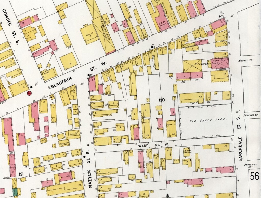
Market Street (little letters on the right) dead ends just north of the middle of my block on Archdale. My block went from Beaufain Street to West Street. Until the city cut an extension of Market Street through from Archdale to Logan Streets. They cut it in a pie shape that took it to Logan Street, Coming Street and Beaufain Street. The pie shape is because Beaufain comes in at an angle…not horizontal as in a grid.
It took me forever to find a reference to the extension being cut through. I’m sure it must be somewhere but not easily found by me. I did find one sentence in a note in an historical article on the Charleston County Library’s site…under Research. (We will get to the subject of that article in chronological order.)
The Charleston Riot of 1919 | Charleston County Public Library (ccpl.org)
Note that the city extended Market Street westward across Archdale to Logan Street at the end of 1952.
This is why the Saks newspaper article from an earlier post can show this photo in 1994:

The black and white Sanford Insurance map from 1955 shows the extension:

Now, here is the chronology I worked out and it may be only of interest to me…
The “Note” above said that the extension was cut through at the end of 1952.
Alderman Hasley told us in the News and Courier article in August 1953 that the city purchased the old church and its graveyard for $1000 “a few weeks earlier” for parking lots. Which is probably the real reason that the pie shaped cut through was made. Finally, more parking lots now on both sides of the street:
22-P022R-Parking-Meter-System-Addendum-3QA-BAM-and-Market (charleston-sc.gov)
So, both sides of Market from Archdale to Logan were parking lots. A scan of newspaper articles about stores on King Street…more later…lamented the lack of parking for people coming into town to shop…many coming down Beaufain Street. That was the plan from the mid-50s until the first Canterbury building was built in 1970…and was behind the beautician of the extension in anticipation of Sak customers coming into town down Beaufain.
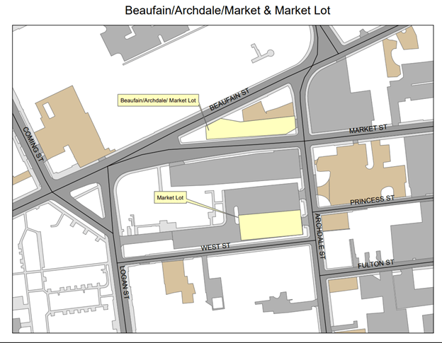
But now we know that a significant section of soon to be metered parking for the city was lost in order to build Canterbury…housing for seniors…a good reason, but lost nonetheless. The map shows what the parking is today…from 2000 on when what was left of their parking bonanza was swapped for the parking at the back of the block on top of the old cemetery.
So…that is more than enough about parking lots! Except for one more thing. Here is a photo of one of the buildings that had been on the original block somewhere near the two buildings remaining at the corner of Beaufain and Archdale that got cut off from my block after the extension. (See the open space in the Saks photo above.) What little businesses and old homes were on my block were demolished and the land purchased at a song by the city. (Except for the one house at the corner of Logan and West…The Huguenot Society at 138 Logan…see that post. The only two buildings left were now not a part of my block…the Saks photo shows it.
I did find one photo that shows one of the lost buildings:

On old maps, the two lots at would have been 37 and 39 Archdale…were my side of the street where Canterbury is now. The old building still across the street, the other corner of Archdale and Market is “40 Archdale” (The tall rectangular building in the 1955 photo above.) So this building “41” Archdale could have been right where the extension cut through…or slightly north right in the parking lot across the Market Street extension.
All the musing got me to take a closer at the old photo…and discovered that there were buildings on either side of the Peerless store. They look old, too, and would have been torn down when this one was. Also…looking closer at the photo, there is a stop sign directly across the street from the building…which says to me that the stop sign was for old Market Street dead-ending into Archdale and the extension to make my Market Street corner ran right through that building!
As often happens, right after clicking “send” one finds something else. Thinking I was finished with this post while looking for something else, I found this among my downloaded Sanborn Maps. This one is 1944 and it shows circled street numbers along Archdale Street and how Market Street dead ends at Archdale…and yes! It shows #35 for the old graveyard, #37 for the old church buildings, nothing at all at what should be #39, not even the number, and #41 exactly where Market Street will get extended right through it.

This is my photo of the two remaining building on Archdale at Beaufain. That old one on the corner looks like the style of the old store with multi businesses above at “41.”

Will explore…

One response to “Back to 1952 and how everything changed…”
It is amazing how you have been able to detail all the changes to your area over time. Local and neighborhood research is fascinating.
LikeLike